All posts by paula

Casa Grande got it’s name from a “big house” built by Indians in about 1300 A.D.

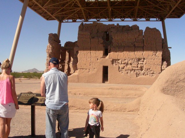
The city of Casa Grande, AZ got it’s name from some Indian ruins nearby.  The ruins include low wall sections from several large compounds in a small area, dominated by a 3-story large structure known as the “big house”.  The big house is much degraded from the elements over several hundred years as well as people climbing on it and damaging it in the 1800s and early 1900s until the government declared it a national park area and worked to preserve it.

In the 1930s a large shade structure was built over the big house to keep it from sun and rain.  Most of the ruins are just low walls so visitors can walk around through some of the old rooms and see the size etc.  The “big house” cannot be entered, but there are windows and doorways that you can walk up to and see into the area.

It’s amazing to see what desert dwelling Indians with no modern tools or materials were able to make such a structure with just mud walls and native tree material for structural support and ladders!  The area was occupied from approx. 900 A.D. through the 1300s but then was abandoned.

We took Zoey, Kira and Zoey’s friend Gigi to see the Casa Grande ruins, it was a very interesting tour!  Here’s the website: Casa Grande National Park website, and here are some pictures:


Amazing Jakes – an indoor game/ride and pizza bonanza!

We’re here in Casa Grande, AZ now, where three of our grandkids live.  We’re having a lot of fun visiting with them.  We spent some time in Amazing Jakes with the family yesterday, the pictures below are of Zoey (12 years old) on a couple of the rides and Kira (5 years old) with Nana (that’s me) on a few of the rides.  Man, was I dizzy after the teacup ride – Kira spun that teacup so fast I thought I’d fly right out the back of it!

Las Vegas – Stratosphere

LOL No, we didn’t do that carnival ride at the very top of the Stratosphere casino where you’re hanging off the edge of a 107 story building while spinning around in a little bucket!  We did see some people heading to the top dressed like skydivers in a one-piece jumpsuit with straps and hooks – they make you wear that apparently so they can safely strap you in!

But we did go to the Stratosphere to eat at the buffet on the ground floor (one of the more reasonable priced buffets in town at $19.95/person).  Then, we went up to the top to see the view.

Their website indicates that it’s $16/person just to go to the top of the tower.  Good grief!  But, the waitress at the buffet told us to say we were going to the lounge up at the top and there’s no charge and a special elevator.  We got to ride in a express elevator that took only 60 seconds to go up 107 floors (our ears popped!)

Great views from the top!  We had forgotten to take the camera so these pictures are from my phone so they’re not as clear as they should have been.  One from the ground looking up shows the view from our trailer – the Stratosphere is on the left and a newer casino is next to it – and the rest of the pictures are from the top:

Devil’s Postpile

While in Lone Pine we drove to Mammoth to see the Devil’s Postpile.  I’m sure everyone has seen pictures of this strange but natural occurrence of lava that cooled and then fractured into vertical columns and now are exposed to view.

The area wasn’t as big as we thought it would be but was very awe-inspiring.  On the way back to the parking area we stopped to see a small falls area from a bridge and were surprised to see more columns, this time not quite vertical but still very strange.  There’s one picture of this formation below as well as the actual Devil’s Postpile:

I was chased down by someone who wants my recipe!

We were getting back from running errands and a lady in a nearby RV ran over to us.  “OH!” she said, “was hoping that I’d catch you.  We were at the same RV park as you a few days ago and as we walked by we could smell the most delicious dinner being cooked!  Can you share the recipe with us?”

Ok, I thought, what was I cooking a few days ago?  I hadn’t cooked too much lately as we’d been doing lengthy day trips while at Lone Pine – so it had to be spaghetti.  I told her I make spaghetti from scratch rather than dump in canned spaghetti sauce with some noodles.  I saute onions, green peppers and garlic, put in a chicken sausage to brown, then add mushrooms, olives, artichoke hearts and plenty of oregano.  I make the sauce by mixing 1 part tomato paste and 2 parts marsala wine (a cooking wine) and stir that in just enough to get it heated up.  Yum!


Lone Pine – site for many Westerns and portal to Mt. Whitney (highest point in cont. US)

On Saturday we drove from Lee Vining down to Lone Pine.  Lone Pine is a small town that is between Mount Whitney, the highest point in the continental US at 14,495 ft, and Death Valley with the lowest point in the continental US at -282 ft.  There’s only about 100 miles between these two extremes!

When we were at Lee Vining we were right next to Mono Lake which had been depleted due to Los Angeles having water rights and using up the lake to supply water to the city.  In the 1990s this was stopped and the lake is slowly getting back up to levels that were common before L.A. started draining it.

Here in Lone Pine we are next to Owens Lake which was completely drained by Los Angeles.  That created huge dust storms and changed the landscape of the area.  Recently Los Angeles was forced to start doing dust mitigation in the lake bed but there’s only a small fraction of the water there used to be.

We’re back in hot country!  It’s dry and dusty and hot here at Lone Pine.  While here we visited Mt. Whitney Portal, a base camp for hikers going to the top of Mt. Whitney.  We also visited fossil falls, a dry falls area (dry because it was fed by Owens Lake which is dry) in an area of lava flows, so what you see is huge black rocks shaped by water flow over a long period of time dropping over 40 ft to the bottom of the falls.  If Owens Lake was still full, there would be a large river dropping over the falls, but since it’s dry you can climb around on the rocks (we didn’t!) and see the shapes made in the lava.  The whole area is very interesting, with volcano cones and lava flows and black rocks all over the place.  There’s a red volcano cone as well, due to different chemicals in the magma that pushed through the surface from that particular volcano right next to other very black cones.

I’m a bit behind in processing the photos that we take but I’ll have some from our day trips from Lone Pine in the next day or two!

Yosemite – words and pictures just don’t it justice

We weren’t planning to visit Yosemite from the east side, but upon looking at a map we realized it wasn’t far at all into Yosemite Valley where the views are magnificent of El Capitan, Half Dome and the Bridal Veil Falls.  So, we went.

We were in awe of how beautiful this area really is.  It’s not something that can be described in words and even really good pictures (let alone ours) cannot do it justice.  So, I’ll just say visiting this fabulous place should be on EVERYONE’s bucket list!  And, September is a great time to go, not too crowded, still warm, perfect!


Lee Vining, CA – within view of Mono Lake

Tuesday morning in Minden NV and we thought we had a day to relax and do nothing before heading south to Mono Lake on Wednesday.

Oops!  About 11:30 we realized that it was the 25th and we had to move TODAY, not tomorrow!  We got the trailer ready to pull out in about a half hour and headed south.  Luckily we keep things fairly tidy in the trailer (have to when 2 people and a dog share a small space!) so it didn’t take long to stow everything.

So now we are at Lee Vining, CA.  From the RV Park we can see part of Mono Lake.  It’s very beautiful here!

Wednesday we went to Bodie, a state park that is a gold mining boom town that was deserted in the 1930s and is now kept in a state of “arrested decay” which means the buildings are maintained for safety and to ensure they don’t fall down but with original material, and several homes, the store, schoolhouse and two churches are available to stand at a window or door and look inside at how the people lived.  Can’t go inside though!  Jeff was hoping to go into the mine buildings but they were closed off.  The cemetary was sad as so many of the headstones are for small children.

Then we went to see the unique “tufas” at Mono Lake.  Mono Lake is fed by several streams coming down from the mountains but has no outlet, so it’s very salty (2.5 times saltier than the ocean).  The minerals in the lake combine and form eruptions that very slowly build up underwater.  Mono Lake had been almost drained providing water to L.A. and other places until the 80s and now the state is trying to get the water level back to the earlier level.  There is an area on the south side where a huge assortment of tufas are now on dry land at the shoreline.  It’s very haunting to walk among them.

Below are pictures of Bodie and of Mono Lake.  Enjoy!


Evening (eastern) sky over Minden

Minden is just south of Carson City and is located in Carson Valley.  The afternoons get VERY windy and another resident of the RV Park stopped by the first day to let us know to close our awning in the afternoons because of the wind.

The day we got here there was a fire over the hill to the south of us, we could see the flames that first evening after dark.  The fire was put out the next day but there was a lot of smoke in the air.

There were a lot of clouds along with the smoke and it make for some great pictures.  This is at sunset but looking east!

Lake Tahoe

Lake Tahoe is just a short drive from where we’re staying in Minden, NV so we took a day and drove over to the lake and then drove around it.  It’s a beautiful lake surrounded by pine and fir trees.  There are a few beaches but most of the coastline is steep and rocky and a lot of people who live near the lake where it’s rocky have built private piers.

We took a few pictures, but it was an overcast day so a lot of the colors of the lake, especially around Emerald Bay, didn’t come out real clear.  But, it was a nice drive and great time for all of us!

From Hiway 50 which we took, there’s a tunnel right on the coast and when we stopped at a nearby vista point we saw the huge rock that the tunnel was carved through.  In the picture I took I put arrows next to the tunnels.