All posts by paula

Earthquake Lake – a lake formed in 1959 when a 7.5 earthquake struck

Not too far from West Yellowstone is a lake that was formed in 1959 when a 7.5 earthquake caused a massive landslide that blocked a river and killed 28 people who were camping in a campground right in the path of the landslide.

On the way we saw some beautiful scenery, and at a bend in the road where there was a very steep cliff along the road we saw a group of mountain sheep with some babies.  Very cute!

Here are some pictures we took:

Yellowstone – first trip into the park

We’ll be here at Yellowstone for a few weeks, so we’ll have plenty of time to take pictures.  On just our first trip into the park we saw lots of bison and a couple of elk, saw Old Faithful erupt, and saw lots of beautiful scenery!

My favorite pictures from today:

And here’s a video I took of the entire Old Faithful eruption: (click here)

And here are a bunch more!

Craters of the Moon – a volcanic landscape like nowhere else!

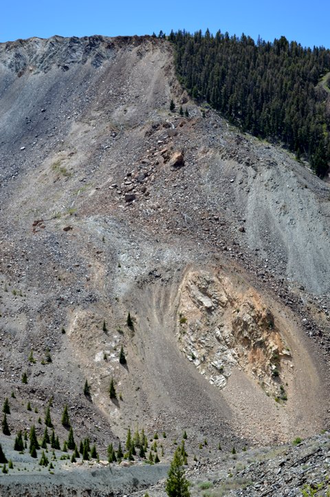
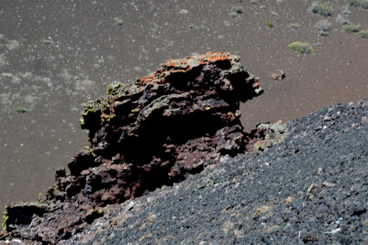
While staying in Idaho Falls we took a drive over to an area known as Craters of the Moon.  It’s an area where there were volcanic eruptions and lava flows every 2,000 years or so from about 16,000 years ago to the latest about 2,100 years ago.  The area contains cinder cones (large conical hills made of black or red cinder rocks), spatter cones (small cones between 10-20 feet high and fairly vertical made of lava that spatters straight up and falls back onto a small area), lava flows and cinder fields.  It’s very interesting to walk among the volcanic material and see all the shapes, flows and colors – in addition to the most common black and fairly common red, there area also areas of blue lava!

A large swath of Idaho following the path of the Snake River is known as the Great Rift, which has seen lots of volcanic activity for thousands of years.  The volcanic activity over these thousands of years has moved northeast and currently Yellowstone is the ‘hot spot’ in the Great Rift.

Here are pictures we took while at the Craters of the Moon:

Dogwood – I’ve never seen it before we headed to northern Ca


As we drive through forests and meadows here in northern CA and southern OR in spring, one type of tree we see often is a dogwood.  In some places they line the roads and are all in bloom.

They are really pretty trees and the white flowers contrast so nicely with the shades of green of the other trees.

We see these trees at altitudes of between 3000 and 4500 feet up, and they only bloom if they are in the sunlight.

We also took close-up shots of another little wildflower and a manzanita in bloom:

Mt. McLoughlin – near Crater Lake

We visited a nearby mountain twice while we were in Shady Cove, OR called Mt. McLoughlin.  The first visit was on a very cloudy day that ended up raining on us so the pictures didn’t come out very good.  So, we took another trip to it on a beautiful, clear day and got some great shots!

On our first trip we went up a dirt road as high up onto the mountain as vehicles are allowed.  From there you have to hike…which we didn’t do 🙂   There was still a lot of snow on the ground and it was cold!

Our second trip we drove around to the east and south of the mountain where there are very pretty lakes.  Beautiful area and definitely worth the second trip!


Crater Lake – the cleanest, purest water on earth

We took a trip to see Crater Lake one day while here in Southern Oregon.  It’s beautiful!  The water is a deep blue, and as it’s pure rainfall (no rivers flow into or out of the caldera) it’s the cleanest, purest water on earth.

The blue of the water was enhanced by the snow all around us!  Here are some pictures:

The Crater Lake Area – over 10′ of snow still there in mid-May!

We drove up to Crater Lake one day while here in Southern Oregon.  Luckily we checked the weather before leaving, because it was in the high 70s at the RV park, but barely 34 up at Crater Lake where there’s still 10′ of snow piled up along the road and blocking the entire first floor of buildings in the area!

Crater Lake was formed by a volcanic eruption approx. 7,700 years ago.  Native American sandals were found in nearby caves buried in the ash, so there were people living in the area when the volcano erupted.

Here are some pictures of the area we saw around Crater Lake:

Rogue River Gorge

Near where we’re staying there’s an area where the Rogue River had carved deep into the volcanic lava tubes that formed along the slopes of Mount Mazana (now Crater Lake).  The gorge was formed when the river caused lava tubes to collapse through this one area.  Here are some pictures: