Stuck in traffic;
is it a workday?
I’m retired
and don’t care –
I smile.
All posts by paula
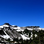
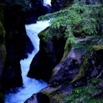
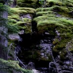
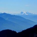
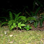
At Mount Baker
Dark, dense forest,
moss and fern.
It clears –
Snow capped mountain
towers above.
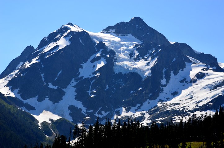
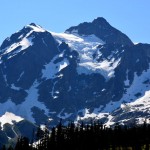
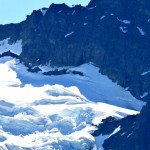
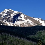
Mount Baker – a glacier capped mountain in Northern Washington
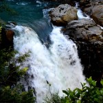
While in Northern Washington we took a day trip to see Mount Baker. We can see it from the coast where we’re staying, jutting up high above the other mountains and hills that we can see from here.
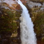
It’s a beautiful mountain, dense forest filled with moss and ferns and waterways and waterfalls. Then we came out from the heavy forest and were in the midst of several glaciers! This trip was actually more interesting than going through the Glacier National Park, as here we were able to drive right into the glacier area.
During the ride I composed a haiku, and decided to start composing them as a sideline so you’ll see a new menu entry with this and one more I’ve composed recently. Here’s my first:
Dark, dense forest,
moss and fern.
It clears –
Snow capped mountain
towers above.
Here are pictures:
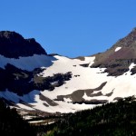
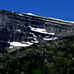
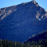
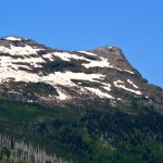
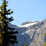
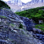
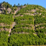
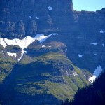
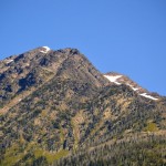
Glacier National Park – very unique!
We’ve spent the last week at Glacier National Park – it’s a very unique place!
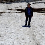
There are very few roads through the park, so you don’t get to see very much of it by car. There are lots of trails, but most are several miles long and are strenuous, so we just opted to see what we could see from the road and a couple of short hikes.
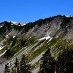
There are only 25 glaciers left in the park – 100 years ago there were over 100! Experts estimate that the glaciers will all be melted by 2030!
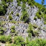
While there are still several glaciers to see, and at least one you can hike through, the major attraction is to see what the glaciers from thousands of years ago did to the mountains as they came through the area. All the mountains within the park contain high, steep-sided mountains with huge horizontal gouges. It becomes very obvious that something very big and relentless scraped its way through these mountains.
We took one hike that crossed several areas of deep snow. I had tennis shoes on (I don’t have any boots) and the snow was very slick in the sun which made it very hard for me to move across the snow. We didn’t go to the end of the hiking area because of that, unfortunately (I’m a wimp, I’ll admit it!)
Here are some pictures of the glaciers and the mountains:


It stays light here till 10pm in northern Montana in July!
Here are a couple of pictures I took one evening at 10pm here in Columbia Falls, MT:


A great dog park in Whitefish, MT
While here in Montana visiting the Glacier National Park, we found a nearby dog park. It’s in Whitefish, just a few minutes away from our RV Park and is called the Hugh Rogers W.A.G. Park (W.A.G. = Whitefish Animal Group). Laddy had a great time running around with the other dogs there!
Here’s my review of this dog park: http://www.bringfido.com/attraction/2688/#reviews
Z’s Meze Market – great Greek food in the middle of Montana
We were only in Bozeman for one day, but wanted to eat out and felt like Greek food as we haven’t had any in several months. Looking online we chose Z’s Meze Market.
It was small, casual, and had GREAT food! Here’s my review of it on Yelp: http://www.yelp.com/biz/zs-meze-market-bozeman#hrid:w8Lce9ZYzp3u1kCN4Ln1_A
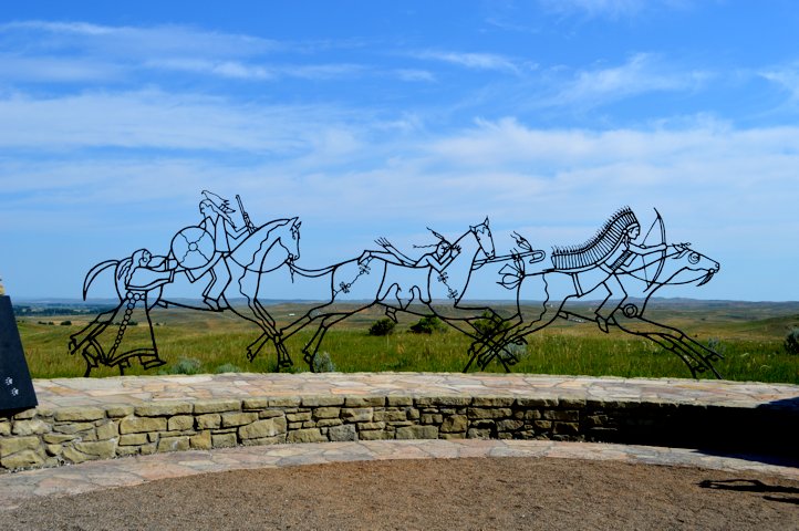
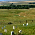
Wildflowers at the Little Big Horn

Little Big Horn – I was surprised to find how ignorant I really was about what happened here!
The battle of the Little Big Horn aka Custer’s Last Stand. I knew very little about this event, basically that Custer and his soldiers had a battle with some native Americans and lost and every man was massacred.
Well, it’s more complex than that! Here’s what I know now about this event after spending a day at the Little Big Horn National Park:
The Sioux and Cheyenne tribes of Montana and Wyoming had been rounded up and put onto a very large reservation after some of their leaders signed a treaty. The bison that they depended on for food, clothing and many other aspects of their lives were decimated and there were NONE on the reservation (the decimation of the bison is another story, but in a nutshell there were an estimated 8MILLION bison in North America in 1840 and only 500 left by 1890. Native Americans didn’t do that, white man did!).
Sitting Bull, Crazy Horse and other native American leaders who had not signed the treaty left the reservation and many others left with them. In December of 1875 the government issued orders – they had 30 days to get back to the reservation or be considered hostiles, in which case they would be forced back or killed. In the middle of the worst winter they had ever seen, there was no way to get the women and children back to the reservation even if they wanted to go (do you think the government did that on purpose?!?) and by June the government sent the cavalry out to get them.
Custer headed one of three commands sent to the area and he had approx. 500 men. There was a command from the south with a little over 1000 men, and one from the west with under 500 men. The command from the south engaged the native Americans first, were driven back easily and they decided to go back to Wyoming and go fishing (this is a true fact!) Custer didn’t know that since there was no way to communicate among the three commands. The command from the west arrived one day too late and to them fell the task of burying the dead.
So Custer, thinking there were two other commands headed towards the native Americans like he was doing, came to the camp. They were astonished to find over 8,000 people, over 2,000 of them warriors in the camp.
Custer divided his command into three sections, and one struck first but was easily pushed back. Custer’s section came from the north, but the native Americans had already routed the first section and rode north to face Custer’s men. This was over 2,000 warriors vs. 263 men with Custer! Custer sent runners to the other two sections saying “Come quickly, bring ammo” but they couldn’t get through. Custer though the other commands would show up, they didn’t.
The battle was very one-sided. Towards the end Custer ordered his men to dismount and shoot their horses to use them as barricades, but it was too late and this action stunned the native Americans into really thinking the white man was crazy, and they killed all the men in Custer’s section. The other two sections were later surrounded and held under siege for over 24 hours until they gave up and were allowed to leave.
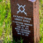
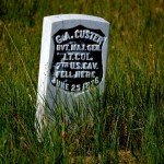
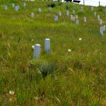
When the command from the west arrived, they and the survivors buried the dead soldiers where they lay. Several years later the dead were all dug up and re-buried in one mass grave with a monument on top. There were headstones placed where each man fell, which shows where the battle was fought. The native Americans took their dead away, but later (like in the 1990s) some headstones were placed where stories from survivors said that it was likely that native Americans had fallen.
The news of this battle reached Washington DC two weeks later, in the middle of the 4th of July festivities on the 100th anniversary of the signing of the Declaration of Independence. The news angered the government, who sent a much larger force west to subdue the native Americans. They were subdued and forced back to the reservation, where almost half died of starvation the next winter while food that was sent to sustain them was withheld from them.
Personally, I’m shocked and saddened at the way the white Europeans treated the native Americans, here and elsewhere during the American history.
Anyway, the national park is fairly small and contains only part of the site of the battle. There’s also a Veteran’s Cemetery on the park, not related to this battle. Veterans from the Spanish-American war, WWI and WWI, Korea and Vietnam are buried here.
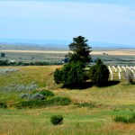
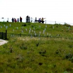
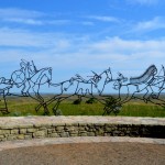
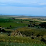
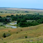
The pictures below show the valley as seen from the site of the battlefield – you can imagine what it would have looked like with 8,000 people living in the valley, the grave markers (look closely, you can see several all over the hillside), and the grave marker of Custer (who was disinterred and taken back to Washington at a later date) and one of the Indian chiefs who died in the battle. Also, there’s a picture of a native American sculpture that was erected along with walls showing some history of the Sioux and Cheyenne people that were engaged in the battle.
Black Hills Cavern – a privately owned cavern!
We visited a second cave in the Black Hills area called the Black Hills Cavern, this one a privately owned cavern instead of a National Park. While it was in many ways very similar to the Wind Cave, we found that there were a lot of differences too. This cavern had flooded totally in 1972 and it took a couple of years to drain it of all the water and mud. That changed the way a lot of the formations look.

We also saw that there were a lot more mineral deposits around this cave. Most likely gemstones as well, but even though privately held, this cavern is under federal protection and no mining can be done here.
Back during prohibition, moonshiners used the cavern to make their liquor and there are a few remnants of it – lots of black on the ceilings in one area where they had fires.
As it’s always been privately owned, the concrete that was poured to make the walkways is not as well maintained as a national park cave is, so it was more treacherous to walk the inclines and the stairways that were narrow and steep and having to duck to one side while going up or down was a bit nerve-racking! But, they had guard rails and the guide was very good about cautioning us when we got to a place with potholes etc. All-in-all, a fun and interesting cave to visit!
Here are some pictures:


